As communities relax COVID-19 restrictions, a recent study by UNC Charlotte geographer Eric Delmelle and two of his former doctoral students could provide decision-makers with timely data about spikes in COVID-19 cases to help guide their decisions.
The research, published in the journal Applied Geography this spring, tracks clusters of COVID-19 down to the county level using space-time statistics. The study is believed to be the first geographic study to use this statistical tracking method and was one of the first studies published by geographers studying COVID-19. In epidemiology, a cluster is a collection of cases of a disease or another health-related condition closely grouped in time and place.
 Lead author Michael Desjardins ’16 M.A. ’19 Ph.D. is a post-doctoral fellow in epidemiology at Johns Hopkins Bloomberg School of Public Health’s Spatial Science for Public Health Center. Alexander Hohl ’11 M.A. ’18 Ph.D., an assistant professor in the Department of Geography at the University of Utah, is the third co-author. Both earned their master's and doctoral degrees in geography at UNC Charlotte.
Their study compares the number of cases to what is expected based on population density, time and other factors, to detect and evaluate whether numbers of cases are actual statistically valid clusters.
 Counties with higher population densities are expected to have more reported cases. The statistical framework of the study examines the cases and population, while comparing the situation “outside” of each county. In short, the clusters of COVID-19 in the study are one or more counties that exhibit significantly more observed cases than what was expected, the researchers indicated.
The researchers came together in part because they knew that their combined expertise gave them significant insights and diverse knowledge.
 Delmelle is a seasoned researcher who has long worked on complex geographic problems. He had collaborated with Desjardins and Hohl while they earned their degrees at UNC Charlotte, and all three have worked with the Center for Applied Geographic Information Science in the Department of Geography and Earth Sciences at UNC Charlotte. Their research collaborations include how geography at national and local levels influences dengue fever, chikungunya and Zika transmission in Colombia. While these diseases are transmitted by mosquitos, the same methods and theory could be applied to COVID-19 research frameworks.
“They both have this additional perspective,” Delmelle said. “They worked really hard when they were here, and they were trained quite well. They were not just in the geography program. They took a lot of courses in other disciplines. This has allowed them to gain additional knowledge and expertise.”
Desjardins immersed himself in public health courses, while Hohl pursued data mining and computing.
Delmelle reached out to his former students a few days after they all started working from home in March as a result of COVID-19 restrictions to see if they could work together.
“I had been wanting to analyze the geography of COVID-19 ever since reports of the epidemic surfaced in the media but struggled with conceptualizing a project,” Hohl said. “Teaming up with Michael and Eric not only allowed me to tap into their analytic and writing skills but also work with friends I share many memories with. Michael and I used to be roommates during our studies at UNC Charlotte and played intramural soccer together.”
The research study came together at a blistering pace, over the span of just a couple of weeks in March. The team used daily county-level case data and did the analysis with the free and publicly available SaTScan software.
Desjardins has expertise with the statistical approach the team used, and he ran the model and wrote the first draft of the paper. Hohl oversaw collecting, processing and analyzing the raw data before the modeling took place and helped with writing and conceptualization. Delmelle helped with conceptualization, writing revisions and producing the maps of their results.
They were drawn to the work by the pressing need of the pandemic and their knowledge that geographers could contribute in meaningful ways.
An inherent link exists between health and place, which means that geographers can play a critical role in disease surveillance and decision-making, the researchers said. They hope that their study will inspire other geographers and epidemiologists to put their unique skills to work on the pandemic. That is one of the main reasons they wanted their study to come out quickly.
“We see a greater number of geographers now who are starting to work on this topic from different perspectives,” Delmelle said. “One thing we were trying to say is, there are some geographic techniques that can be applied to dealing with this pandemic.”
To date, geographers and epidemiologists in Idaho, São Paulo (Brazil), Quebec and Malaysia have applied their approach to monitor emerging clusters in their regions.
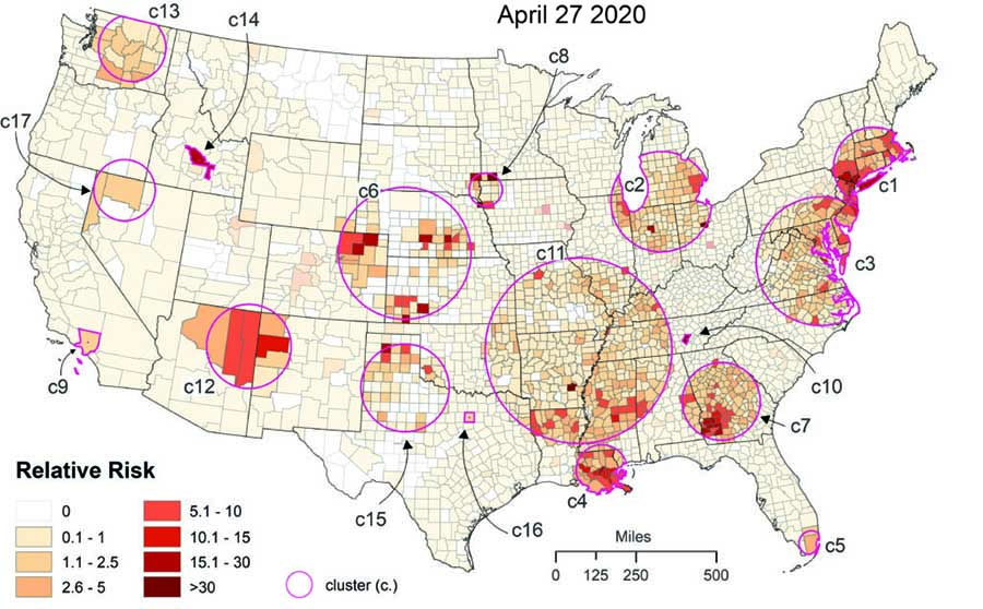
Because the software is free and readily available, the analysis can be re-run again and again. The researchers have run the results again on April 27 (as seen in Figure 1), after the research paper was published. They found that small clusters were growing into larger clusters in some areas.
“Southwest Georgia seems to be a serious problem, which is something we already detected back on March 27 and seems persistent,” Delmelle said. Georgia, meanwhile, is a state that is aggressively re-opening and easing restrictions.
One caveat the authors note is the uncertainty of the data. The true number of COVID-19 infections is still unknown, due to limited testing and other issues. They also note that just because a county does not belong to a cluster does not mean COVID-19 is not or will not be an issue. Clustering studies serve to help prioritize resources to mitigate transmission in the most affected areas, they say.
“You could also use the cluster detection method, where you could identify a county that has had a reported number of cases, and then you implement some sort of measures, and you run this cluster analysis again, and you can assess whether the measures seem to have had an impact,” Delmelle said.
In the same way, researchers can run the analysis after social distancing and other measures are relaxed to see if clusters rise over time.
Meanwhile, the three are exploring their next steps. They plan to continue collaborating on the pandemic. They know they work well as a team – even when socially distant.
UNC Charlotte’s Ph.D. in Geography program reflects the multidisciplinary research and teaching expertise of its exceptional and award-winning faculty. Graduate students engage in coursework from within and across three areas of focus: Urban and Regional Analysis, Earth and Environmental Systems and Geographic Information Science.